Traveling is one of life’s greatest adventures—but nothing derails that experience quite like getting lost in an unfamiliar city, missing a crucial turn on a hiking trail, or arriving late because you misunderstood a train map. Fortunately, in the age of GPS, mobile apps, and digital tools, it’s easier than ever to stay on course. However, smart navigation is not just about downloading an app—it’s about having the right tools, habits, and backup plans to ensure you never get lost again.
Whether you’re navigating bustling urban landscapes, wandering scenic countryside, or trekking through remote regions, this comprehensive guide will equip you with the travel mapping essentials you need to navigate like a local, avoid stress, and make the most of your journey.
1. Why Navigation Is Critical to a Great Travel Experience
Getting from point A to point B sounds simple, but when you’re in a foreign country with unfamiliar languages, confusing signage, and limited internet access, it becomes a real challenge.
Accurate navigation helps you:
- Stay safe and avoid dangerous areas.
- Find attractions, accommodations, and transportation efficiently.
- Save time and energy.
- Explore hidden gems off the beaten path.
With the right mapping tools and strategies, every destination becomes more accessible, and your trip becomes more enjoyable.
2. The Basics: Digital Maps and Navigation Apps
The foundation of modern travel mapping is digital maps. They provide turn-by-turn directions, estimated arrival times, route options, and real-time updates.
Essential Mapping Apps:
- Google Maps: The most comprehensive and globally used navigation app. It offers driving, walking, biking, and transit directions.
- Apple Maps: Smooth interface for iOS users, with integrated features like Apple CarPlay.
- Maps.me: Best for offline navigation and walking trails; great for remote travel.
- HERE WeGo: Excellent for offline use, especially for cities with public transit.
- Waze: Best for drivers; relies on real-time user input to suggest the fastest routes.
Pro Tips:
- Download offline maps before you travel.
- Learn to use saved locations and label your hotel, restaurants, and must-see places.
- Use layers like public transport, terrain, and satellite for richer context.
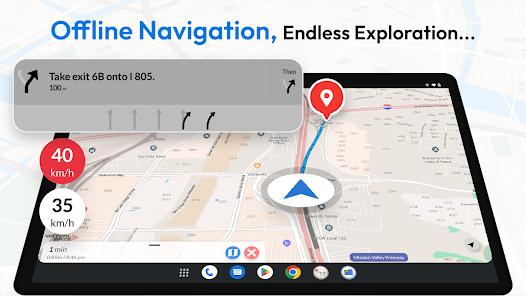
3. Offline Navigation Is a Lifesaver
Internet access isn’t guaranteed everywhere. When you’re in the mountains, rural villages, or underground subway systems, offline navigation becomes essential.
Steps to Prepare:
- Download offline maps of your destination using Google Maps or Maps.me.
- Keep a charged power bank to ensure your phone doesn’t die mid-route.
- Print a paper map as a last-resort backup, especially for hikes or isolated areas.
Offline maps still allow you to:
- Search addresses.
- Use GPS (which doesn’t require data).
- Follow routes on foot or by vehicle.
4. Paper Maps: Old-School but Reliable
Though they might seem outdated, paper maps remain invaluable in emergencies. They’re immune to battery failure, signal loss, and app crashes.
Why Bring a Paper Map:
- Useful for remote travel and hiking where GPS may be inaccurate.
- Helps visualize broader areas without zooming in and out.
- Allows for easier trip planning and route marking.
Look for:
- City tourist maps (often free at hotels or airports).
- Trail maps for national parks or rural areas.
- Laminated, waterproof versions for outdoor adventures.
5. Specialized Travel Apps for Navigation
Beyond basic maps, there are specialized apps for specific types of travel. These tools enhance your navigation and planning experience.
A. Public Transit:
- Citymapper: Integrates buses, trains, and subways in major cities worldwide. Includes live departure times and fare calculators.
- Moovit: Covers thousands of cities and gives real-time transit data.
- Transit: Simple interface and real-time crowding information.
B. Hiking & Nature Trails:
- AllTrails: Offers detailed hiking, biking, and running trail maps.
- Komoot: Great for multi-day hikes and offline topographic maps.
- Gaia GPS: Used by serious hikers for backcountry routes and terrain data.
C. Driving & Road Trips:
- Roadtrippers: Plan and map custom road trips with interesting stops.
- iOverlander: Useful for overland and van travelers for campsites and facilities.
6. Use GPS and Compass Functions Effectively
Modern smartphones come with built-in GPS, compass, and gyroscope features, allowing you to pinpoint your location even without a signal.
Best Practices:
- Calibrate your compass regularly (many apps will prompt this).
- Learn to use longitude and latitude coordinates in case of emergency.
- Use your compass when hiking or navigating without visual landmarks.
Understanding basic orientation can help you stay on track even if all apps fail.
7. Plan Routes Before You Leave
Smart travelers know that good planning reduces confusion later. Before heading out, map your destinations and mark essential spots.
Must-Mark Locations:
- Hotel or lodging.
- Public transport stations.
- Embassies or medical facilities.
- Key attractions, restaurants, and meeting points.
Use the “Star” or “Label” feature in Google Maps or Maps.me to easily access your key spots.
8. Language and Map Reading
Sometimes maps or signs may be in a language you don’t understand. A few tips will keep you from getting lost in translation.
Tips:
- Learn key words like “Exit,” “North,” “Station,” “Stop,” and “Street.”
- Use translation apps like Google Translate to read signs via camera.
- Match landmarks or shapes from maps with what you see in the real world.
Maps with visual landmarks like rivers, large buildings, or parks help orient you when language becomes a barrier.
9. Stay Safe with Real-Time Tracking
Mapping tools can also enhance your safety. Share your location in real time with family or travel partners.
Apps That Offer Real-Time Sharing:
- Google Maps: Share your live location for a set duration.
- WhatsApp or Telegram: Use “Live Location” in chat.
- Find My iPhone / Find My Device: Helps in lost phone situations.
In remote or unsafe areas, knowing someone can see your location is a major safety net.
10. Learn the Local Transport System
Getting around a new city isn’t just about streets. Understanding the transportation network is key to avoiding confusion and delays.
Understand:
- Subway lines and color codes.
- Bus numbers and routes.
- Timetables and rush hour schedules.
- Taxi zones and ride-share pickup points.
Local apps or printed transit maps can often be found at airport kiosks or transit stations, and many hotels will offer simplified versions.
11. Take Photos for Reference
If you know you’ll be offline later, photograph essential map details for offline use.
Examples:
- Hotel address and neighborhood map.
- Transit maps and walking directions.
- Screenshot routes from your navigation app.
Save them in a dedicated folder in your phone gallery for quick access.
12. Ask for Directions The Smart Way
Sometimes technology can’t help—and asking locals becomes the best option.
How to Do It:
- Have a picture or map ready to point at.
- Learn basic phrases in the local language like:
- “Where is…?”
- “How far is…?”
- “Which way to…?”
- Use landmarks rather than addresses.
Many locals are happy to help when approached politely. Combine verbal directions with your map to double-check accuracy.
13. Be Aware of Mapping App Limitations
Even the best apps aren’t perfect. Don’t follow them blindly.
Watch out for:
- Outdated maps in developing regions.
- Incorrect walking routes through unsafe or restricted areas.
- Detours during construction or closures.
Always use your instincts and environment in combination with your mapping tools.
14. Keep Your Devices Powered
Even the most advanced tools are useless with a dead battery.
Essentials to Carry:
- Power bank (10,000mAh or higher).
- Extra charging cables.
- Plug adapter for international sockets.
- Solar charger if hiking or camping.
Always charge your phone overnight and top up during meals or downtime.
15. Embrace Spontaneity—With a Map in Hand
While having a route is important, sometimes the best experiences come from wandering and exploring.
With reliable maps in your pocket, you can:
- Roam freely and still find your way back.
- Discover cafes, alleys, or street art off-route.
- Follow curiosity without fear of getting lost.
The goal is not to restrict exploration, but to enhance it with confidence.
Conclusion: Your Map, Your Freedom
In the end, mastering travel mapping isn’t just about knowing where you are—it’s about feeling confident no matter where you go. With the right mix of apps, offline tools, practical habits, and a spirit of curiosity, you’ll never feel lost—even if the road is unfamiliar.
So next time you head abroad, don’t just pack clothes and toiletries. Pack your navigation toolkit—digital and analog—and open the door to a safer, smoother, and far more enriching travel experience.
Never get lost again. Just get going.